Contents
Streatham: A 19th century dormitory suburb
by Graham Gower
The Beginning of Modern Streatham
The first ripples of suburban development reached Streatham during the last decades of the 18th century. Around this time the economics of large-scale farming were showing signs of decline. This had stimulated some local landowners, such as the Duke of Bedford, to sell or lease parcels of land for building or commercial purposes.
Those who purchased or leased land were often merchants or businessmen, looking to establish a family seat or retreat in the countryside. Taken out of ancient farmland or from cleared woodland, these new estates, with their mansions encompassed by ornamental grounds, were soon to become a marked feature in the Streatham countryside. Their boundary walls often reflected ancient field boundaries, later to be fossilised as back garden fences or as street or building lines as modern development took place. These new homes for the nouveau gentry were to contrast vividly with the traditional prospect of rustic farmhouses and ploughed fields.
Turn of the
Century Streatham
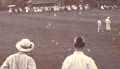
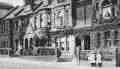
Streatham Cricket Club
1902
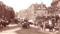
Streatham High Road
1903
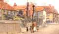
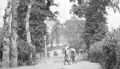
Greyhound Lane
1904
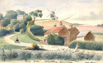
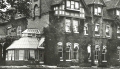
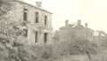
Leigham Court Estate
c.1905
Streatham Vale Road
1905
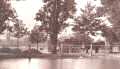
Top Pond
c.1905
Woodfield
c. 1905
Lonesome
1905
Others took up land for speculative purposes, building villa or terrace-type properties along the main roads of the parish. This was in response to a demand for new housing, which had been stimulated by the expansion of metropolitan London. Since the 18th century southwards expansion from London had occurred as ribbon development along the principal thoroughfares, including the Brixton and Clapham Roads.
The opening up of southwest London for house building had found a further stimulus in the construction of two new Thames bridges. During the late 1730s building began on Westminster Bridge and by 1820 another bridge at Vauxhall had been completed.
These two river crossings gave access to the growing and fashionable West End of London. Although new building had been taking place within the parish, mainly as infill developments, growth had remained almost static. However at Balham events were different. Here new land was eagerly taken up for building purposes.
The Early Suburban Development of Balham
It was at Balham that suburban development, albeit on a small scale, first occurred within the parish. From the 1780s properties of varying size were built along Balham Hill and could be seen as an extension of residential development taking place around Clapham Common. The attendant effect on this part of the parish was the creation of new shops, businesses, services and an accompanying increase in the population.
One other effect was the fostering of Balham's identity, which was further encouraged in 1808 when a proprietary chapel was opened on the outskirts of the village, much to the enthusiasm of the inhabitants. In many ways this was to set the seal for Balham's future and, along with a developing social infrastructure, gradually placed her apart from the rest of the parish, determining her eventual separation from Streatham.
The Growth in Streatham’s Population
During the late 18th and early 19th centuries the population of Streatham parish was beginning to show signs of growth. But in comparison with the adjoining parishes of Clapham and Wandsworth it was still small.
In 1725 the population of the parish was recorded as being “about 400 people” with the adjoining parish of Tooting Graveney (Lower Tooting) having some "230 souls above the age of 14 years”, and Clapham having about "1300 or 1400 souls". By 1788 Streatham parish could count "about 500" inhabitants with Tooting Graveney only reaching “1020” and Clapham with "about 2500" inhabitants.
In his Environs of London, published in 1792, Daniel Lysons offers us a more reliable count of Streatham's population; this being 1,590 inhabitants occupying 265 houses. With the census of 1801 we obtain our first accurate population count of 2,357 people, which reached 2,729 by the 1811 census with just over 400 houses occupied.
This protracted growth in the local population continued until 1831 when the census returns for Streatham parish show the population had risen to 5,068 people with 834 houses lying across the parish. During the following decades the population was to increase dramatically, rising steadily from the late 1870s when Streatham received the first effects of suburbanisation.
The period 1780 to 1830 marked the initial stages in the transition of Streatham from a rural parish to a London suburb. During this period an estimated 250 houses were built across the parish. Many of these were put up during the 1820s, and although the number was small it was sufficient to herald the eventual demise of old Streatham.
Early Development at Streatham Hill
It was at Streatham Hill that the first residential area was established in Streatham proper. This entailed the building of a number of stylised villas and cottage type properties along the west side of the highway towards Brixton Hill. At the top of the hill some limited house building had already occurred just north of Mill Lane (now Moorish Road).
An integral part of the Streatham Hill development was the laying out of Streatham Place. This planned road anticipated the construction of similar roads that were soon to criss-cross the parish in anticipation of housing developments. South of Streatham Place the "Paragon" was developed; a row of twenty fashionable stucco styled properties, planned to be a main feature in this newly designed residential area. With the unfolding of the 1830s, further house building took place in this area with the construction of numerous small terraced properties and shops along the north end of Bleak Hall Lane, an old country lane renamed New Park Road in 1884.
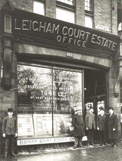
Leigham Court Road
A number of large detached mansions also began appearing along the east side of Streatham High Road towards what is now Leigham Court Road. This road was another planned thoroughfare aimed at opening up what had been farmland for speculative building purposes.
Beriah Drew, a shrewd and capable developer, laid out the road, which was part of an ambitious development scheme, in 1839 across the lands of Mount Nod Farm. Three years earlier, Drew had purchased the land from the devisees of Lord Thurlow's estate, who had been the Lord of the Manor of Leigham Court. The new road was named St. Julian's Road and not designated Leigham Court Road until 1902.
House building in this road commenced at the high road end during the early 1840s with the building of a number of large well-proportioned mansions. The building of similar properties in nearby Leigham Avenue complemented these. Previously the road had been the track way to the farmhouse of Mount Nod Farm.
In anticipation of further residential development, partly stimulated by the opening of Streatham Hill Railway station in 1856, an extension of Leigham Court Road was made from Streatham High Road towards Tooting Bec Common. This was named Leigham Court Road West, later, in 1864, to be renamed Drewstead Road in commemoration of the Drew family. The road was laid out during the early 1860s, probably with the aim of crossing the common to link Streatham Hill with Balham. The link with Balham was not achieved and house building along the road was erratic, not being completed until the 1930s.
19th Century Developments at Balham
Similar residential developments were extending the bounds of Balham where new roads were taking shape, notably Balham New Road, where the Loat family, who owned a local building firm, was putting up small cheap properties.
From the early 1820s larger and more expensive types of property began appearing along Balham High Road south of Bedford Hill Road. Richardson Borradaile, a speculative builder constructed Bedford Hill House, a substantial property built on land previously part of Covey's Farm.
At a later date Richardson Borradaile was to lie out the carriageway to Bedford Hill House as a thoroughfare in anticipation of future house building. However, this was slow to materialise, and it was not until the 1870s before the road saw any substantial building. On completion, in 1891, it was renamed as Bedford Hill.
Developments at Tooting Bec
With subsequent building taking place along Balham High Road southwards from Balham Hill, and infill developments within Balham proper, ribbon development had almost reached the bounds of Tooting Bec village. This began at Wandsworth Lane, now known as Trinity Road. Southwards from here along Upper Tooting Road, little modern development had taken place; the old village looked much the same. South beyond the village, from approximately Hebdon Road, most of the land flanking the highway still presented a rural view until reaching the village of Tooting Graveney. This stretch of road was dominated by a number of large 18th century mansions. Notable among these were Park Holme, The Manor House and Lynwood; grand houses standing in acres of ornamental ground. It was not until Totterdown Street was reached that limited suburban development could be seen, generated by the northward growth of Tooting Graveney village, now Lower Tooting.
By the mid 1890s suburban building was beginning to overtake the village of Tooting Bec and this part of Streatham parish. High profile commercial building appeared along Upper Tooting Road and a pattern of residential side streets were built, including the well known Totterdown Estate, built by the London County Council during the late 1900s. Building continued in and around Tooting Bec, now commonly called Upper Tooting, until the late 1920s with the completion of the Bell estate, which centred on Fishponds Road.
The Demise of Agriculture
In between the stately mansions, which dotted Streatham parish, were the scattered fields of the local farms. Although farming was still an integral part of parish life, signs of decline were becoming evident during the late 18th century. Land previously farmed for root crops or grain was now being landscaped or used for pasture.
Large mansions such as Furzedown House, Streatham Lodge and Bedford Hill House had gradually replaced the old farming estates. Agricultural land not taken up for building or parkland was being used for market gardening or dairy farming. Produce from these concerns found ready markets in London as well as supplying local demands. Nevertheless, such was the loss of local farmland, by 1840 only 720 acres of arable land remained within the parish.
This was further emphasised by the marked decline during the period 1811 to 1831 in families engaged in agriculture and the increase of those engaged in some form of trade or manufacture. Moreover, there was the demand for people to work in the large country houses as servants, cooks, gardeners and grooms, and the increasing need to employ people in the retailing sector.
These demands brought new people into Streatham. Some of these newcomers were farm workers affected by changes in the countryside, such as low agricultural wages, poor living conditions, mechanisation and enclosures. Furthermore, they were attracted by employment prospects offered in the expanding metropolis of London.
The rise in local population during the coming decades was to bring irreversible change to Streatham. The class structure was to be altered through a rising middle class, and there were to be radical changes to the local environment. These events, in turn, were to bring pressure on the limited resources and organisation of the parish vestry. This authority had, since the 18th century, taken over much of the administrative work of the manor courts, and did much to regulate local affairs.
In earlier centuries the local population had shown little increase and at times had been almost static. With the general increase in the national population during the 19th century coupled with the influx of people into Streatham, the local population quickly increased. By 1850 the population was approaching 7,000 inhabitants. In the adjoining parish of Clapham the figure was much higher, reaching to more than 16,000. This was due to the nearness of Clapham to London, although in size the parish was smaller than Streatham. At Wandsworth, again a smaller parish, the population was higher, numbering around 10,000. The comparative smallness of Streatham's population reflected the continuing rural nature of the parish: a situation, however, that was not to last.