History of Dulwich
Dulwich is unique in south east London. One body, the Dulwich Estate, has owned and administered the area for almost 400 years. Edward Alleyn purchased the manor of Dulwich (the name means ‘the place where the dill grows’) in 1606, and since then revenue from the estate has been used for various charitable purposes, including maintaining a school. This school has evolved into Dulwich College and other associated educational establishments. The Estate has always exerted close control over the area, only allowing developments that would be of maximum long-term benefit to the institutions it supported and which would be attractive to the parents of scholars. This resulted in a relatively few large, high-quality and well-maintained houses (which, it was judged, would hold value better than many smaller ones), an overwhelmingly middle class population and area that has the character of a semi-rural outer suburb rather than somewhere less than six miles from the City.
In 1901 Dulwich’s population was considerably less than today’s total; this is an extraordinary fact as the figures for the population of areas that bounded it to its north, east and west were double those of today. Homes on the estate fall into four broad categories: a very small number of older mansions such as Belair, built at the end of the 18th century for the wealthiest of merchants; a series of large detached villas which were were built 1860-80, mainly on the southern side of the estate; later smaller semi-detached houses built north of the village; and even, under pressure from the Camberwell Borough Council, working class housing in the northern part of the estate, usually close to its boundary.
Dulwich provides a perfect example as to how one factor (in this instance an extremely powerful freeholder) can totally dominate – and in this case inhibit – the prevalent process of development even when all other factors that would normally encourage it – demand for housing, suitable employment, transport and willing builders – are in place.
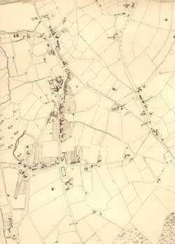
This section of the Dewhirst map of Camberwell (above) shows the heart of the Dulwich Estate. Lacking a parish church, the village evolved two centres depending on inclination: the College or the public house, the Greyhound.
Click on the map for a larger view or click here for a readable version which may be slow to download.
The village was the commercial centre but there are large detached houses on the main road south, which later became College Road, and on Dulwich Common. Belair, with its extensive grounds and fishpond, is particularly prominent.
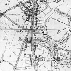
This 1894 map (right) emphatically shows the successful development of the Dulwich Estate during the 19th century.
Click on the map for a larger and wider view or click here for a readable version which may be slow to download.
The village retains its shape of a century previous, but there are two important changes to its edges: Dulwich Park, which opened in 1890, and the Charles Barry buildings of the Dulwich College of 1870.
To the north-west new roads have been laid out, awaiting the erection of generously proportioned terraces, semis and villas. The Estate (and parish) boundary is shown by the dark line west of the railway on the left of the map, and over that boundary development is markedly more intense.
Stanford Ordnance Survey Map, 1894.


