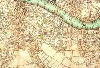
Map of Bermondsey, 1787
This map shows Bermondsey before its suburban development.
The map is not easy to read unless enlarged, as the symbols used to depict trees and market gardens can easily be confused with buildings.
Recently built turnpikes are in evidence on Greenwich (now Old Kent) Road and Blue Anchor (now Southwark Park) Road.
New roads have also been built: the first section of (Bermondsey) New Road, which later became (Old) Jamaica Road, and what is now Dunton Road.
Tanning is a prominent industry and the ditches and streams that supported this activity are evident near Neckinger and just west of St Saviours Dock.
Extract from John Cary's New and Accurate Plan of London and Westminster, the Borough of Southwark and parts adjacent: viz. Kensington, Chelsea, Islington, Hackney, Walworth , Newington, with an Alphabetic List of upwards of 500 of the principal Streets with references to their situation. Printed in 1787.
Click on the map above for an enlarged image or click here for a larger, readable image.


