History of Borough
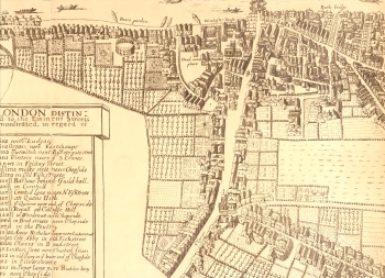
The earliest map of Southwark available, dated 1658, clearly shows the shape of the ancient town, known as the Borough.
Click on the map to enlarge, or click here for a readable version (slower download).
It was made up of five main roads: Borough High Street running south from London Bridge; Kent Street running south east from Borough High Street; Tooley Street heading east from London Bridge; Bermondsey Street running off Tooley Street; and finally, Bankside heading west along the riverside and ending in the marsh.
A bearpit, very close to where Shakespeare's Globe Theatre would originally have been, can be seen close to Bankside. Winchester House, the London residence of the bishop of Winchester, is on the river, close to the bridge. Development is concentrated on the higher and drier land east of the high street.
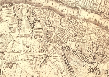
The second map engraving is dated 1769. Although only 25 years separate the original edition of Roque with this revision, the changes that had taken place were to have a tremendous impact on Southwark.
Click on the map to enlarge, or click here for a readable version (slower download).
Blackfriars Road, Borough Road and other boulevards leading to St George's Circus have been laid over the waste of St George's Fields and the ancient street pattern with the confident sweep of a town planner's vision of the future not the past.
New building took place on the northern section of Blackfriars Road, but at rather a later date on St George's Fields. Ribbon development took place along Blackman Street (now the southern portion of Borough High Street), Kent Street and Long Lane. This engraving of Blackfriars Bridge is dated 1796, but it was shown on the 1769 map, which was the year it opened. There are several marked 'tenter grounds' on the map: fields or areas of open ground where washed new cloth was stretched out on tenter hooks to dry.
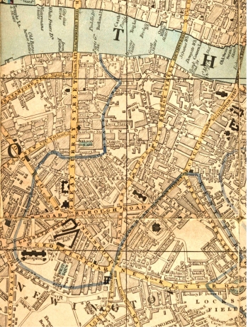
By 1835 (map, right) virtually all of north Southwark had been developed. New Thames bridges and the draining of St George's Fields 25 years earlier, made this possible.
Click on the map to enlarge, or click here for a readable version (slower download).
Note the many institutions near St.George's Circus including Bethlem Hospital. Guy's Hospital, close to London Bridge also appears on the map.
While some of the newer developments were of a grand scale and quality, e.g. West Square, Trinity Square and the Paragon, much newer building was aimed at the working classes.
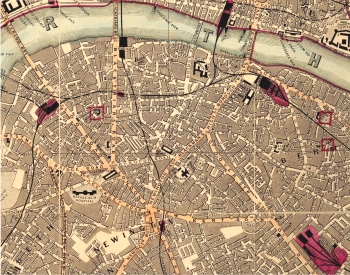
The final map (below) is dated 1870 and shows Borough and Bankside at their most densely urbanised, and the riverside area just past its peak population.
Prominent is the improved transport infrastructure, notably the recently completed railway extensions to Cannon Street, Charing Cross and Blackfriars.
The Bricklayers Arms Goods Depot is also prominent.
The Magdalen Hospital (for Penitent Prostitutes) just north of St George's Circus was shortly to move - it had become surrounded by the vice it had hoped to escape - and the site was to be built on by a Peabody estate, an early example of philanthropic housing in the area.


