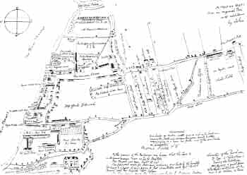
Map of Deptford, 1623
Deptford was a town of two parts, the old
fishing village at Deptford Strond beside the
Thames, and the settlement around Deptford
Broadway, close to Deptford Bridge, which depended
economically upon the traffic along the Dover
Road.
Only the former is shown on this
1623 map, which belonged to John Evelyn, the
diarist.
It shows the importance of
shipbuilding in Deptford by this time, with the
Royal Dockyard at the bottom of the map (the west)
and the East India Company's yard closer to
Deptford Creek.
Inland there were still few houses.
Anonymous manuscript map of 1623, with annotations by John Evelyn
Click on the map above for an enlarged image or click here for a larger, readable image (slow download).


