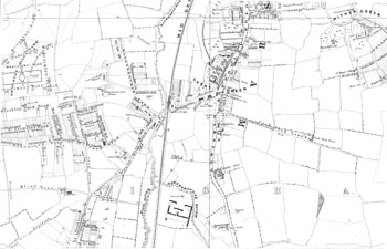
Map of Catford, 1877
Catford is now firmly centred on the town
hall and the shopping precinct, but in 1877
that part was still usually known as Rushey
(or Rushy) Green.
The town hall ('Bd. Of Wks.' on the
map) was then two years old. The name
'Catford' was used for the area to the west,
around the bridge and mill.
In Rushey Green the development was
still mainly restricted to the enclosed
common land west of the main road.
Otherwise the main feature was the luxury estate of Ravensbourne Park, which was laid out in the 1820s.
Click on the map above for an enlarged image or click here for a larger, readable image (slow download).
Stanford's Library Map 1877.


