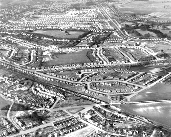
Aerial View of Chelsfield, Bromley, 1955
This view looks north over the London to Sevenoaks Railway (in the deep cutting running bottom right to middle left). It shows suburban Chelsfield - the ancient village centre is almost a mile to the east.
Most of Chelsfield's suburban development dates from the 1930s, though there has been subsequent infill such as on the site of what was Orpington Secondary School (the large field in the centre of the view).
This view shows two significant transport links: the railway (the line dates from 1865 and Chelmsfield station from 1868), and the Orpington bypass of the 1920s.
Copyright Topham Picture Library. Contact Bromley Local Studies and Archives


